
Motorways are major anthropogenic infrastructures that significantly alter natural ecosystems and act as environmental stressors, affecting the physiology, behavior, and distribution of wildlife populations. This study evaluated the impact of the China–Pakistan Economic Corridor (CPEC) roadway on wildlife habitat, population density, and road mortality in District Mansehra, Khyber Pakhtunkhwa (KP), Pakistan. Road construction and increased traffic contribute to habitat destruction and fragmentation, restrict animal movement, and increase wildlife mortality through vehicle collisions. Wildlife–vehicle collisions pose significant ecological, social, and economic challenges worldwide. Driven transect surveys were conducted over a one-year period (November 2022–October 2023). The study section of the CPEC was divided into five zones to assess wildlife mortality. A total of 128 road-killed vertebrates representing five taxonomic orders were recorded. The highest proportion of road kills (25.7%) occurred between Qalandar Abad and the Mansehra Tunnel, followed by the stretch between the Mansehra Tunnel and Dhodihal Interchange (17.1%). The jackal (Canis aureus) was the most frequently recorded species (36.7%), whereas the house sparrow (Passer domesticus) accounted for the lowest mortality (3.1%). Seasonal analysis revealed that road kills were most frequent during summer (42.1%), followed by winter (15.6%). The findings provide baseline information on wildlife mortality patterns, habitat conditions, and species distribution along the CPEC in District Mansehra. These results can support the development of targeted mitigation measures and conservation strategies to reduce wildlife–vehicle collisions and protect biodiversity in the region.
Research Article · Online First, 20 November 2026 · Open Access
Impact of China-Pakistan Economic Corridor (CPEC) Project on the Population Density and Habitat of Wildlife in District Mansehra
, , ,
Affiliations & Notes ⌄
- 1Department of Zoology, Hazara University, Mansehra, KP, Pakistan
- 2Department of Botany, Hazara University, Mansehra, KP, Pakistan
- *Correspondence | Adnan Ayaz; Email: adnanayaz1350@gmail.com
Article Info ⌄
- Journal:
- Pakistan Journal of Zoology
- Submitted Date:
- 12 August 2025
- Revision Date:
- 5 August 2026
- Accepted Date:
- 25 August 2026
- Published Date:
- 20 November 2026
Abstract
INTRODUCTION
Construction of roads and highways has an impact on wildlife since it directly destroys and fragments habitat, introduces a source of additive road kills for wildlife populations, and obstructs animal migration and dispersal . In general, roads reduce habitat size and quality, reduce landscape connectivity, increase mortality, and modify animal behaviour, all of which collectively have detrimental impact on species abundance . Roads may have a significant negative impact on animals because they frequently result in deadly accidents between moving automobiles . In landscape scale inquiries, the impact of roads and habitat degradation on wildlife populations is often assessed using several factors. The effects of habitat loss are typically evaluated by analyzing the relationship between the proportion of natural habitat within a landscape and species distribution or abundance. In contrast, the impacts of roads are generally assessed by examining the correlation between road or traffic density, or the distance to the nearest road, and patterns of species distribution or abundance ; . Most of these roads are not physically secure against access by animals, and they are marked by relatively high traffic volumes and travel speeds. On highways and motorways, appropriate fences and animal crossings are typically installed. On the other hand, the A-18b warning sign for “wild animals” is the most employed option on highways with lower technical classifications . The distribution of these numerous free-ranging animals, especially in the northern half of the country, may, according to some theories, be the cause of high accident rates seen here. Intriguingly, red deer Cervus elaphus collision rates in Europe were low relative to their abundance, a pattern that may be explained by the exclusion of the huge southern populations in fenced-in areas . The high collision rates observed in the study area may be explained by the prevalence of these free-ranging animals, particularly in the northern part of the country. Red deer collision rates were interestingly low in relation to abundance, a pattern that might be explained by the large southern populations being kept out of fenced-in areas . Although the incidence of roadkills in relation to abundance is higher on more used roads, the local abundance of toads Bufo bufo and frogs (amphibian, numerous species) is negatively correlated with traffic density on nearby roads . Roads can act as demographic barriers bearing distinct habitats and populations . The fragmentation of natural ecosystems is one of the greatest risks to biodiversity resulting from past and contemporary human activities. This process results in the gradual isolation and surface decrease of the natural regions, which changes the dynamics and structure of several delicate plant and animal species . Globally, WVCs have considerable negative social, economic, and ecological effects . Evaluating the present and potential future effects of the world’s road network on wildlife is essential given the possibility that roads might have a negative influence on biodiversity. Roadkill, or the death of wildlife because of collisions with automobiles, is sometimes seen as one of the most catastrophic effects of roadways and is a substantial source of anthropogenic mortality for several species .
This study aims to investigate the impacts of the China-Pakistan Economic Corridor on the population density and natural habitats of native wild animal species in District Mansehra. Additionally, it seeks to collect and analyses road-kill data along the CPEC route within the district to assess the extent of mortality caused by vehicular traffic and infrastructure development.
MATERIALS AND METHODS
Study area
This study was conducted in Mansehra District, located in the Hazara Division of Khyber Pakhtunkhwa (KP), Pakistan. The district lies between latitudes 34°14′–35°11′ North and longitudes 72°49′–74°08′ East. It is bordered by Battagram and Kohistan districts to the north, Muzaffarabad District (Azad Jammu and Kashmir) to the east, Abbottabad and Haripur districts to the south, and Swat District to the west. The total land area of Mansehra District is approximately 4,579 km² (1,768 sq mi). The research was conducted along the China–Pakistan Economic Corridor (CPEC) route passing through Mansehra District. The total length of the CPEC stretch within the district is 46 km (approximately 28.6 miles). The study area encompasses several villages as well as urban settlements, with a mean elevation of approximately 1,238 m above sea level (asl). For systematic sampling, the 46-km route was divided into five zones: (1) 8 km from Qalandar Abad to Mansehra Tunnel; (2) 10 km from Mansehra Tunnel to Dhodihal Interchange; (3) 10 km from Dhodihal Interchange to Ichrian Interchange; (4) 10 km from Ichrian Interchange to Karmong Tunnel; and (5) 8 km from Karmong Tunnel to Battal Tunnel (Fig. 1).
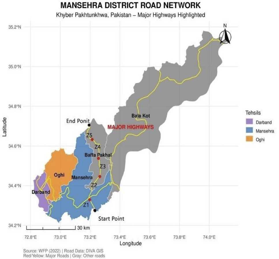
Map of study area.
Field survey
Field studies and the collection of samples from wild animal road kills were conducted in the designated areas of the CPEC in District Mansehra (KP), Pakistan, between November 2022 and October 2023. Each of the five zones was visited during fieldwork in order to collect samples. Surveys were conducted on the utilization of wild animal habitat at a given population density and the impact of road kills on the habitat and population of wild animals in their natural habitat. The following tools were utilized to collect data: notebook, rubber, pencil, questionnaire paper, global positioning system (GPS), and camera. Data were collected directly by point count methods.
Survey was conducted on a four day per month schedule (typically from Thursday to Sunday) to conduct focused transect drives for eight hours (06:00-18:00 excluding rest hours) covering the five designated study zones of CPEC in District Mansehra to collect data on the population status and road killed wild animals observed on the road to determine population density in its natural range. On weekdays, the traffic density is normally higher between the hours of (07:0009:00 and 13:00-16:00), and on weekends, from Saturday evening to Sunday, between the hours of (18:00 and 06:00). However, currently, no traffic monitoring data are available. Every month, four-point counts were conducted in each of the research area’s zones to identify the road parameters and population status.
For each transect, surveys were conducted by driving in the same direction at an average speed of 45 km/h, with the driver simultaneously serving as the observer . Road killings were limited to the three recorded taxonomic categories of animals viz., mammals, birds, and reptiles . A global positioning system (GPS) (Garmin Vista Etrex 10, Olathe, KS, USA) was used to record the elevation and geographic location of each roadkill along with a photo to confirm identification and prevent recounts . Road kills were only counted if they were seen on the road and not on the road verges to balance the chance of detection and computed highway kills occurrence using the Arc-GIC 10.1 software and Google Earth Pro. The status of each species found to be a roadkill was determined according to Red List categories of the International Union for Conservation of Nature (IUCN). Each designated point along the CPEC was surveyed by driving a stretch of 8–10 km, depending on the respective zone. Road kills were recorded using direct and indirect measures viz., direct observation and interviews with the local community, traffic police and vehicle drivers. Thus, good data were collected. Daytime was used for gathering indirect information.
Data analysis
To account for the frequency of road hits for each species, the population density was calculated by dividing the total number of road hit species by the total number of road kills. This allowed us to compute the relative frequency of highway hits. For data analysis, we employed parametric tests because our data had a normal distribution. A one-sample t-test was used to compare annual road mortality rates for habitat, and a single-factor ANOVA test was used to evaluate road kills in three temporal categories: monthly, seasonal, and annual. Spatial traffic fatal accident data were classified by road and zone using the geographic information system. GIS maps were created by Google Earth Pro and Arc-GIC 10.1 software.
RESULTS
We surveyed a total of 46 km of the CPEC corridor daily over a 48-day period, accumulating 768 survey hours (mean: 8 h/day; survey time: 06:00–18:00). The study area was divided into five zones: (1) Qalandarabad to Mansehra Tunnel (8 km); (2) Mansehra Tunnel to Dhodial University Interchange (10 km); (3) Dhodial University Interchange to Ichrian Interchange (10 km); (4) Ichrian Interchange to Karmang Tunnel (10 km); and (5) Karmang Tunnel to Battal Tunnel (8 km).
Population density
A total of 128 road kills were recorded during a 48-day survey conducted between November 2022 and October 2023. The highest roadkill density was recorded in the Qalandarabad to Mansehra Tunnel zone (0.71 road kills/km), followed by the Ichrian Interchange to Karmong Tunnel zone (0.56 road kills/km), the Karmong Tunnel to Battal Tunnel zone (0.52 road kills/km), the Dhodihal Interchange to Ichrian Interchange zone (0.50 road kills/km), and the Mansehra Tunnel to Dhodihal Interchange zone (0.47 road kills/km) (Table I).
Across the five study zones, a total of 128 roadkill incidents were recorded, including 107 mammals, 17 reptiles, and 4 birds. Among the mammals, 47 individuals were jackals (Canis aureus), 21 were porcupines (Hystrix indica), and 39 were wild boars (Sus scrofa). Reptile road kills consisted of 12 snakes and 5 monitor lizards (Varanus spp.), while avian mortality was limited to 4 house sparrows (Passer domesticus) observed during the study period (Table II).
Table I. Wild animal road kills on the CPEC, district Mansehra KP, Pakistan during November 2022- October 2023.
|
Zone |
Zone length km |
Frequency of road kills |
% of road kills |
Cumulative road kill/km |
|
Qalandarabad to mansehra tunnel |
8 |
33 |
25.7 |
0.71 |
|
Mansehra tunnel to dhodihal interchange |
10 |
22 |
17.1 |
0,47 |
|
Dhodihal interchange to ichrain interchange |
10 |
23 |
17.9 |
0.50 |
|
Ichrain interchange to karmong tunnel |
10 |
26 |
20.3 |
0.56 |
|
Karmong tunnel to battal tunnel |
8 |
24 |
18.7 |
0.52 |
|
Total |
46 |
128 |
99.7 |
2.76 |
Table II. Road killed species identified in study area of CPEC, District Mansehra, KP, Pakistan during November 2022- October 2023.
|
Class |
Species name |
Zoological name |
IUCN status. |
Road kills. |
% of road kills |
Road kills/km. |
|
Mammalia |
Jackal |
Canis aureus |
LC |
47 |
36.7 |
1.02 |
|
Porcupine |
Hystrix indica |
LC |
21 |
16.4 |
0.45 |
|
|
Wild boar |
Sus scrofa |
39 |
30.4 |
0.84 |
||
|
Total |
107 |
83.5 |
2.32 |
|||
|
Reptile |
Snake |
Lycodon aulicus |
LC |
12 |
9.3 |
0.26 |
|
Monitor lizard |
Varanus monitor |
5 |
3.9 |
0.1 |
||
|
Total |
17 |
15.9 |
0.36 |
|||
|
Aves |
House Sparrow |
Passer domesticus |
LC |
4 |
3.1 |
0.08 |
Road kills variation during different seasons
The highest number of road kills was recorded during the summer season, with 54 incidents, followed by 29 in autumn, 25 in spring, and 20 in winter (Fig. 2). Analysis of variance (ANOVA) indicated that seasonal variation in roadkill numbers was not statistically significant (p > 0.05). The composition of wildlife species recorded along the CPEC in District Mansehra including mammals, reptiles, and birds is illustrated in Supplementary Figure 1.
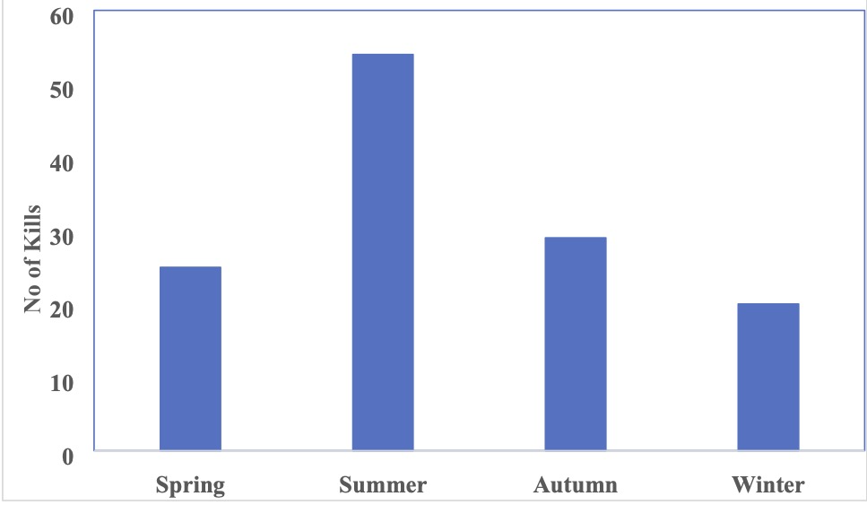
Seasonal road kills of animal reported on CPEC in District Mansehra (2022-2023).
Habitat
The study area covered about 46 km of CPEC in District Mansehra located at 34° 14’ and 35° 11’ North latitudes and 72° 49’ and 74° 08’ East longitude. Habitats were divided into two ecological zones, subtropical Chir pine (Pinus roxburghii) zone and subtropical and moist temperate Ecotone. An ecotone is the area where two ecological zones join each other, here they share indicator species.
The subtropical Chir pine zone, extending approximately 38 km from Qaladrabad to the Kurmang tunnel at an average elevation of 1244 m asl, is characterized by a distinct stratified floral structure. The overstory is dominated by Pinus roxburghii (Chir pine), which forms the primary canopy alongside other significant tree species such as Dalbergia sissoo (locally known as Tahli or Shisham), Populus ciliata (Himalayan Poplar), and the fast-growing Ailanthus altissima (Tree of Heaven/Dharawa). The arboreal layer also includes Prosopis juliflora (Mesquite) and Robinia pseudoacacia, known locally as Walayati kikar or Black locust.
The middle-story and shrub layer are defined by ecologically resilient species, including Dodonaea viscosa (Sanatha), Indigofera heterantha (Kanthee), Isodon rugosus (Wrinkled Leaf Isodon), and Rubus fruticosus (wild blackberry). The herbaceous and ground cover layer consists of a variety of grasses and forbs, notably Cynodon dactylon (khabbal), Digitaria ciliaris (Southern crabgrass), and Rumex hastatus (arrowleaf dock). Additionally, the zone is inhabited by Tagetes minuta (wild marigold) and the widespread invasive weed Parthenium hysterophorus, locally referred to as Carrot booti or Gajjar booti.
The second ecological zone is the Subtropical Moist Temperate Ecotone, which extends approximately 8 km from the Kurmang tunnel to the Battal tunnel. This transitional zone is situated at an average elevation of 1388 m asl and exhibits a unique overlap of floral species from both lower and higher altitudinal regimes. The coniferous overstory is characterized by the presence of Pinus wallichiana (blue pine/kail) and Pinus roxburghii (chir pine), alongside broad-leaved trees such as Populus ciliata (Himalayan poplar), Ailanthus altissima (tree of heaven/dharawa), Prosopis juliflora (mesquite), and Robinia pseudoacacia (black locust/walayati kikar).
The shrub layer remains dense and diverse, featuring Dodonaea viscosa (sanatha), Indigofera heterantha (kanthee), Isodon rugosus (wrinkled leaf isodon), and Rubus fruticosus (wild blackberry). The ground cover is dominated by various herbaceous species and grasses, including Trifolium repens (white clover/shahtal), Rumex hastatus (arrowleaf dock), Tagetes minuta (wild marigold), and the invasive Parthenium hysterophorus (gajjar booti/carrot booti). Additionally, the graminoid Cynodon dactylon (khabbal) continues to serve as a significant component of the lower vegetation stratum.
The majority of roadkill incidents were recorded within the subtropical Chir pine zone, primarily due to the extensive coverage of the China–Pakistan Economic Corridor (CPEC) infrastructure within this ecological belt. Owing to its larger spatial extent, the subtropical Chir pine zone accounted for the highest number of road kills (n= 104). In contrast, the subtropical moist temperate ecotone exhibited a considerably lower frequency of roadkill incidents. Statistical analysis confirmed this disparity, with a t-test indicating a significant difference in mortality rates between the two zones (t = -0.62, df = 5, p < 0.05) (Table III).
Table III. Variation (Difference) in roadkill incidences in two habitats.
|
Common name |
Scientific |
Roadkill (N) |
Difference |
|
|
Zone 1 |
Zone 2 |
|||
|
Jackal |
Canis aurius |
38 |
9 |
-29 |
|
Porcupine |
Hystrix indicus |
16 |
5 |
-11 |
|
Wild Boar |
Sus scrofa |
33 |
6 |
-27 |
|
Snake |
Lycodon aulicus |
10 |
2 |
-8 |
|
Monitor Lizard |
Varanus monitor |
5 |
0 |
-5 |
|
Sparrow |
Passer domesticus |
2 |
2 |
0 |
DISCUSSION
Construction of roads and highways has an impact on wildlife since it directly destroys and fragments the habitat, hinders animal migration and dispersal and adds a source of cumulative mortality to wildlife populations. Carnivores and herbivores were the most heavily affected orders, accounting for the majority of road mortality among mammals. This is probably because the home ranges of carnivores are larger than those of lesser animals while carnivores that feed on hunted/dead animal bodies on the road run the risk of turning into road kills themselves . Additionally, locals’ disposal of automobile carcasses on road may also contribute to road kills. In one instance, we saw jackal eating a dead chicken located on the road. The darkness also makes it harder for cars to see the moving animals .
Pakistan’s wildlife is threatened by numerous factors, such as disease, poaching, and habitat loss . Even through other countries acknowledge the threat posed by road death losses ; ; in Pakistan, it is not regarded as a threat, and there is little information of road deaths. Due to their proximity to protected regions, this road section (Mansehra tunnel to Kurmang tunnel road) has a high species richness . There is a dearth of information regarding road kills, and no research has been done on it, hence Pakistan does not consider it to be a problem. Because of this, it is challenging to correlate the data from our study with those from other regions of Pakistan, even though it would be reasonable to compare the road fatality rates with research from other countries.
Road mortality is caused by the particular road-crossing behaviour of many mammalian species [e.g., the Porcupine ; which curls up in a ball in response to the predator affecting them to be motionless, not observable by the motorists while driving, turning them into roadkill. Road kills of reptiles contributed 15.9% of our data. Reptiles particularly snakes , for the purpose of thermoregulation, are drawn to highways and frequently bake in the daytime heat on warm road surfaces, which increases their risk of being killed . This feature is especially prevalent in the winter months when the snakes must thermoregulate to survive. Birds accounted for only 3.1% of our road kills data, which contrasts with numerous previous research carried out globally (Rowdan et al., 2008). Roadside habitat provides microhabitats that are used by birds and due to their feeding and flight patterns near roadways they frequently get struck by passing cars . Electric pylons have the potential to kill birds, but cars are less likely to damage them when they collide with them.
In contrast to other studies carried out elsewhere in the world, the District of Mansehra has high incidence of road deaths. For example, mammals road kills were 2/km compared to 0.1 mammals/km in South Africa and 0.04 mammals/km in Tanzania . Road kill of reptiles (0.36 roadkill/km) was approximately similar as compared to 0.8 roadkill/km in Limpopo Province of South Africa and 0.02 reptile roadkill/km in Tanzania . However, almost equal to (0.08 roadkill/km) 0.1 birds/km in South Africa and 0.07 birds/km in Tanzania . Road kill rates can be attributed to a variety of factors, including traffic flow, speed limits, driver perceptibility and road geometry.
Zone three of the road (Mansehra tunnel to Kurmang tunnel) recorded more roadkill frequency on the CPEC than other zones. This is probably because this section is situated in more urban areas, that means that there is more traffic on them . Similar results were reported by Langbein et al. (2010) in New York on national routes.
This could also help to explain why there were more traffic fatalities on particular roads than others. Roads in unprotected area had fewer road kills than those next to protected areas. This may be because protected areas were unaltered sections of the ecosystem, and as such, they should support a wider variety and richness of animals. Therefore, compared to unprotected areas, which can have fewer wildlife species in lower abundance, more animals could emerge onto the nearby roads, leading to higher number of road kills. The published literature supports this finding as well, with several earlier studies by Garriga et al. (2012) and Kioko et al. (2015). Studies on road kills in safe regions around the world have shown comparable outcome in Tanzania and Spain, correspondingly. Road kills on roads within safe areas are likely more common, which can be attributed mostly to the differences in wildlife abundance between safe and unprotected areas.
Although several research indicate that road kills peak during the summer, we anticipated finding of even more roadkill during this time . Road killings probably increase because of seasonal change in animal behavioral cycle, such as reproduction . During this time a variety of carnivore species can be found on CPEC, such as jackal. Additionally, in Pakistan, the breeding season for birds and reptiles runs from April to October ; . The summer had the highest number of road kills whereas spring and winter had the lowest number, as predicted.
Over the course of the study, we saw a little decrease in road mortality, which may have been caused by the CPEC’s removal of tree cover, which increased animal visibility when crossing roads . Wildlife frequently looks for exposed spaces beside roadways to use as passageways to cross them .
The highways can have a significant impact on animal communities by directly causing road kills and dividing populations . The highway studied had a major impact on mammals. One could state that the high roadkill rate is caused both by the recent motorway opening and the increase in traffic. It is possible to estimate how many road kills will result from habitat alteration but may be stabilized later . The real barrier effect caused by road building and traffic was exacerbated by environmental instability and disruption . Some have hypothesized that because mammals were reluctant to travel into open areas, roads served as behavioral barriers that prevented them from moving . We can justifiably assume that the construction of a motorway caused an instantaneous decline in animal population and a real insulation of the populace. In order to protect local people and reduce the impact on ecosystem equilibrium, it is evident that research on migration and population exchange is necessary before building motorways.
Conclusion
The present study demonstrates that the China Pakistan Economic Corridor (CPEC) has significantly affected wildlife populations and habitats in District Mansehra by fragmenting habitats, restricting animal movement, and increasing roadkill. A total of 128 roadkill incidents were recorded, with mammals being the most affected group, particularly during summer and in the subtropical Chir pine zone. The findings provide important baseline data on wildlife mortality and habitat use, highlighting the influence of road infrastructure on biodiversity. The study emphasizes the need for effective mitigation measures, including wildlife crossings, traffic regulation, and habitat management, to reduce roadkill and promote sustainable infrastructure development while conserving wildlife.
Declarations
Acknowledgement
We would like to acknowledge the Wildlife Department, Khyber Pakhtunkhwa (KP), Pakistan, for its valuable cooperation, support, and assistance during the study.
Funding
No funds, grants, or other support was received for this information.
Authors’ Contribution
AA, writing original draft, investigation, writing review and editing; SN, supervision; SG, methodology, supervision, writing review and editing; AM, data analysis. All authors read and approved the final version of the manuscript.
Ethical statement and IRB approval
The study was conducted in accordance with relevant institutional and national guidelines for wildlife research and con-servation. No animals were captured, handled, or experimentally manipulated during the study. Road-killed wildlife specimens were recorded and identified through field surveys conducted along the China–Pakistan Economic Corridor (CPEC) in District Mansehra, Khyber Pakhtunkhwa, Pakistan. All field observations were carried out in a manner that minimized disturbance to wildlife and their natural habitats. Necessary permissions for field surveys were obtained from the relevant authorities, where applicable.
Supplementary material
There is supplementary material associated with this article. Access the material online at: https://dx.doi.org/10.17582/journal.pjz/20250812062011
Generative AI and AI assisted technology statement
The authors declare that no generative AI and AI assisted technology was used in the creation of this manuscript.
Statement of conflict of interest
The authors have declared no conflict of interest.
References
- Akrim, F., Fatima, H., Nazir, S., Mahmood, T., Hussain, R. and Nadeem, M.S., 2017. Seasonal hormones, female reproductive tract changes, and some field observations onbreeding activities of the small Indian mongoose (Herpestes javanicus) from its native range of Potohar Plateau, Pakistan. Turk. J. Zool., 41: 664-673. https://doi.org/10.3906/zoo-1512-14 [CrossRef]
- Akrim, F., Mahmood, T., Andleeb, S., Hussain, R. and Collinson, W.J., 2019. Spatiotemporal patterns of wildlife road mortality in the Pothwar Plateau, Pakistan. Mammalia, 83: 487495. https://doi.org/10.1515/mammalia-2017-0101 [CrossRef]
- Bennett, V.J., 2017. Effects of road density and pattern on the conservation of species and biodiversity. Curr. Landsc. Ecol. Rep., 2: 1-11. https://doi.org/10.1007/s40823-017-0020-6 [CrossRef]
- Cahill, S., Llimona, F. and Gràcia, J., 2003. Spacing and nocturnal activity of wild boar Sus scrofa in a Mediterranean metropolitan park. Wildl. Biol., 9: 3-13. https://doi.org/10.2981/wlb.2003.058 [CrossRef]
- Caro, T., Shargel, J. and Stoner, C., 2000. Frequency of medium-sized mammal road kills in an agricultural landscape in California. Am. Midland Natur., 144: 362-369. https://doi.org/10.1674/0003-0031(2000)144[0362:FOMSMR]2.0.CO;2 [CrossRef]
- Chen, H.L. and Koprowski, J.L., 2016. Barrier effects of roads on an endangered forest obligate: Influences of traffic, road edges, and gaps. Biol. Conserv., 199: 33-40. https://doi.org/10.1016/j.biocon.2016.03.017 [CrossRef]
- Clevenger, A.P., Chruszcz, B. and Gunson, K.E., 2001. Highway mitigation fencing reduces wildlife- vehicle collisions. Wildl. Soc. Bull., pp. 646-653.
- Coffin, J., Blomberg, J., Fan, H., Gifford, R., Hatziioannou, T., Lindemann, D. and Johnson, W.J.J., 2021. ICTV virus taxonomy profile: Retroviridae 2021. J. Gen. Virol., 102: 001712. https://doi.org/10.1099/jgv.0.001712 [CrossRef]
- Garriga, N., Santos, X., Montori, A., Richter-Boix, A., Franch, M. and Llorente, G.A., 2012. Are protected areas truly protected? The impact of road traffic on vertebrate fauna. J. Biodiv. Conserv., 21: 27612774. https://doi.org/10.1007/s10531-012-0332-0 [CrossRef]
- Guinard, É., Prodon, R. and Barbraud, C., 2015. Case study: A robust method to obtain defendable data on wildlife mortality. Handb. Road Ecol., pp. 96-100. https://doi.org/10.1002/9781118568170.ch12 [CrossRef]
- Haigh, A.J., 2012. Annual patterns of mammalian mortality on Irish roads. Hystrix, 23: 58.
- Henry, D.A., Collinson-Jonker, W.J., Davies-Mostert, H.T., Nicholson, S.K., Roxburgh, L. and Parker, D.M., 2021. Optimising the cost of roadkill surveys based on an analysis of carcass persistence. J. environ. Manage., 291: 112664. https://doi.org/10.1016/j.jenvman.2021.112664 [CrossRef]
- Hill, J.E., DeVault, T.L. and Belant, J.L., 2019. Cause-specific mortality of the world’s terrestrial vertebrates. Glob. Ecol. Biogeogr., 28: 680-689. https://doi.org/10.1111/geb.12881 [CrossRef]
- Huijser, M.P., McGowan, P., Hardy, A., Kociolek, A., Clevenger, A., Smith, D. and Ament, R., 2017. Wildlife-vehicle collision reduction study: Report to congress. Report to Congress. Report Number: FHWA-HRT-08-034. https://rosap.ntl.bts.gov/view/dot/88021
- Johnson, D.L. and Lewis, L.A., 2007. Land degradation: Creation and destruction. Bloomsbury Publishing PLC.
- Kambourova-Ivanova, N., Koshev, Y., Popgeorgiev, G., Ragyov, D., Pavlova, M., Mollov, I. and Nedialkov, N., 2012. Effect of traffic on mortality of amphibians, reptiles, birds and mammals on two types of roads between Pazardzhik and Plovdiv region (Bulgaria)– Preliminary results. Acta Zool. Bulg., 64: 57-67.
- Khan, M.S., 2006. Amphibians and reptiles of Pakistan: Krieger Publishing Company Malabar, Florida, USA.
- Kioko, J., Kiffner, C., Jenkins, N. and Collinson, W.J., 2015. Wildlife roadkill patterns on a major highway in northern Tanzania. Afr. Zool., 50: 17-22. https://doi.org/10.1080/15627020.2015.1021161 [CrossRef]
- Krukowicz, T., Firląg, K. and Chrobot, P., 2022. Spatiotemporal analysis of road crashes with animals in Poland. Sustainability, 14: 1253. https://doi.org/10.3390/su14031253 [CrossRef]
- Lala, F., Chiyo, P.I., Kanga, E., Omondi, P., Ngene, S., Severud, W.J. and Bump, J.J.H., 2021. Wildlife roadkill in the Tsavo Ecosystem, Kenya: Identifying hotspots, potential drivers, and affected species. Heliyon, 7: e06364. https://doi.org/10.1016/j.heliyon.2021.e06364 [CrossRef]
- Langbein, J., Putman, R. and Pokorny, B., 2010. Traffic collisions involving deer and other ungulates in Europe and available measures for mitigation. In: Ungulate management in Europe: Problems practices (eds. R. Putman, M. Apollonio, R. Endersm). Cambridge University Press, 2011: 215-259. https://doi.org/10.1017/CBO9780511974137.009 [CrossRef]
- Lima, S.L., Blackwell, B.F., DeVault, T.L. and Fernández-Juricic, E., 2015. Animal reactions to oncoming vehicles: A conceptual review. Biol. Rev., 90: 60-76. https://doi.org/10.1111/brv.12093 [CrossRef]
- Lode, T., 2000. Effect of a motorway on mortality and isolation of wildlife populations. AMBIO: J. Hum. Environ., 29: 163-166. https://doi.org/10.1579/0044-7447-29.3.163 [CrossRef]
- Melia, S., 2015. Urban transport without the hot air: Volume 1: Sustainable solutions for UK cities. Bloomsbury Publishing.
- Mohapatra, R.K. and Panda, S., 2013. Behavioural sampling techniques and activity pattern of Indian Pangolin Manis crassicaudata (Mammalia: Manidae) in captivity. J. Threat. Taxa, pp. 5247-5255. https://doi.org/10.11609/JoTT.o3423.5247-55 [CrossRef]
- Mulero, A., 2013. El-paisaje forestal-cinegético en Sierra Morena: Una Lectura geográfica. Cuadernos Geográficos, 52: 108-128.
- Prosser, P., Nattrass, C., Prosser, C. and Safety, E., 2008. Rate of removal of bird carcasses in arable farmland by predators and scavengers. Ecotoxicology, 71: 601-608. https://doi.org/10.1016/j.ecoenv.2007.10.013 [CrossRef]
- Quintana, S.M., Ramos, B.M., Martínez, M.C. and Pastor, I.O., 2010. A model for assessing habitat fragmentation caused by new infrastructures in extensive territories–Evaluation of the impact of the Spanish strategic infrastructure and transport plan. J. environ. Manage., 91: 10871096. https://doi.org/10.1016/j.jenvman.2009.12.013 [CrossRef]
- Rais, M., Baloch, S., Rehman, J., Anwar, M., Hussain, I. and Mahmood, T., 1997. Diversity and conservation of amphibians and reptiles in North Punjab, Pakistan. Bridges, 1999: 2000.
- Riitters, K.H. and Wickham, J.D., 2003. How far to the nearest road? Front. Ecol. Environ., 390: 125-129. https://doi.org/10.1890/1540-9295(2003)001[0125:HFTTNR]2.0.CO;2 [CrossRef]
- Row, J.R., Blouin-Demers, G. and Weatherhead, P.J., 2007. Demographic effects of road mortality in black 392 ratsnakes (Elaphe obsoleta). Biol. Conserv., 137: 117-124. https://doi.org/10.1016/j.biocon.2007.01.020 [CrossRef]
- Rowden, P., Steinhardt, D. and Sheehan, M., 2008. Road crashes involving animals in Australia. Accid. Anal. Prev., 40: 1865–1871. https://doi.org/10.1016/j.aap.2008.08.002 [CrossRef]
- Rytwinski, T. and Fahrig, L., 2011. Reproductive rate and body size predict road impacts on mammal abundance. Handb. 394 Ecol. Appl., 21: 589-600. https://doi.org/10.1890/10-0968.1 [CrossRef]
- Rytwinski, T. and Fahrig, L., 2015. The impacts of roads and traffic on terrestrial animal populations. Handb. 396 Road Ecol., pp. 237-246. https://doi.org/10.1002/9781118568170.ch28 [CrossRef]
- Teixeira, F.Z., Rytwinski, T. and Fahrig, L., 2020. Inference in road ecology research: What we know versus what we think we know. Biol. Lett., 16: 20200140. https://doi.org/10.1098/rsbl.2020.0140 [CrossRef]
- Torres, A., Patterson, C. and Jaeger, J.A., 2022. Advancing the consideration of ecological connectivity in environmental assessment: Synthesis and next steps forward. Impact assessment and project appraisal. 40: 451-459. https://doi.org/10.1080/14615517.2022.2134619 [CrossRef]
- Tsiakiris, R., Stara, K., Pantis, J. and Sgardelis, S., 2009. Microhabitat selection by three common bird species of montane farmlands in northern Greece. Environ. Manage., 44: 874- 887. https://doi.org/10.1007/s00267-009-9359-8 [CrossRef]
- Umar, M., Hussain, M., Murtaza, G., Shaheen, F.A. and Zafar, F., 2018. Ecological concerns of migratory birds 405 in Pakistan: A review. Punjab Univ. J. Zool., 33: 69-76. https://doi.org/10.17582/pujz/2018.33.1.69.76 [CrossRef]
- Underhill, J.E., 2003. Roads and wildlife: A study of the effects of roads on mammals in roadside habitats. University of Birmingham.
- Visintin, C., Van Der Ree, R. and McCarthy, M.A., 2016. A simple framework for a complex problem? Predicting wildlife–vehicle collisions. Ecol. Evol., 6: 6409-6421. https://doi.org/10.1002/ece3.2306 [CrossRef]
- Wendy, C.J., Parker, D.M., Bernard, R.T.F., Reilly, B.K. and Davies-Mostert, H.T., 2014. Wildlife road traffic accidents: A standardized protocol for counting flattened fauna. Ecol. Evol., 4: 3060–3071. https://doi.org/10.1002/ece3.1097 [CrossRef]

Services
Article usage statistics
Loading…
Related articles
- Socio-economic impacts of billion tree afforestation project in district Buner, Khyber Pakhtunkhwa, PakistanPakistan Journal of Forestry · 2024
- Impact of Feeding Habits on Population Ecology and Breeding Biology of Grey Francolin (Francolinus pondicerianus) in District Bhakkar, Punjab, PakistanPakistan Journal of Zoology · 2021
- Differential Impact of Different Land-Use Types on the Population Density and Community Assemblages of Edaphic Macroinvertebrates in District Sargodha, Punjab, PakistanPakistan Journal of Zoology · 2018
- Population Densities of Melon Fruit Fly Bactrocera cucurbitae (Coquillett) in Vegetables Agro-Ecosystem in District Hyderabad, Sindh, PakistanSarhad Journal of Agriculture · 2017
- Socio-Economic Development of Small Farmers by Providing Micro-Credit Facilities under the Crop Maximization Project in District Charsadda, PakistanSarhad Journal of Agriculture · 2020
- Population Ecology of Chakor Partridge (Alectoris chukar) in District Bajaur, Khyber Pakhtunkhwa, PakistanPakistan Journal of Zoology · 2021